Monday, April 28, 2014

Sydney, Australia

What more can be said about Sydney? It's a city that's a destination unto itself, boasting more annual international visitors than any other locale in Australia.  It lures in tourists with its laid back lifestyle, sunny weather, great beaches, its stunning natural beauty on the harbor and of course, its iconic bridge and opera house.  Apparently many of those tourists choose never to leave since it is also one of the most ethnically diverse cities on the planet.  It's a city that is full of glitz and glamour and wealth that borders on the obscene; the city is host to some of the largest malls I have ever seen in my life. Many of them tower 6 stories and take some 3 city blocks with have three or four food courts and over 500 stores!  

It may come as a surprise to you then, that I was and remain quite underwhelmed with Sydney.  There is just nothing about the city that is uniquely Australian.  In fact once I pulled myself away from the hypnotic draw of the harbor I found myself thinking I could be in any city.  There is a distinct lack of character and originality that leaves the city feeling sterile and bland.  Perhaps it's the overly commercialized nature of the place, what with propagation of the aforementioned malls and the modern steel & concrete luxury apartment complexes making up the majority of the buildings in the inner city.  Perhaps it just isn't what I expected Australia to be like.  Admittedly I do think more of the outback as being quintessentially Australian, maybe due to watching too many nature documentaries as a child.  Whatever the reason, I'm having a really difficult time finding anything endearing enough to hold onto.  I just can't catch vibe of the city.  This is disappointing, as I was really hoping my first impression would prove incorrect as we spent more time exploring the city.  Looks like once again I'm the odd man out that doesn't see the appeal in something that everyone else seems to love.  That isn't to say that our time spent here hasn't been enjoyable, so I'll tell you now about some of the cities highlights.

There is no denying the beauty of the Sydney Harbour.  The first glimpse that I caught of it was staring down George Street through the dense concrete jungle.  I could see the arch of the harbor bridge and I was captivated.  So together Kayleigh and I made our way up the length of George and before long we'd cleared the high rises and were staring in awe at the dramatic scene before us.  It was a surreal moment.  The bridge seemed so much bigger than I'd imagined, and the Opera House so much more impressive.  So many times have we seen images of it, and here we were seeing it with our own eyes.  If we'd wanted, we could have walked right up and touched it (we did at a later time).  There was a cruise ship the size of a high-rise apartment block docked in the harbor, an engineering marvel all its own somehow maintaining buoyancy on the water.    

A floating city! 
Our first glimpse of the bridge!
The most beautiful building on earth
The Sydney skyline along the Sydney Harbor

The dynamic duo at dusk

Another of Sydney's gems are the beaches.  Bondi Beach is undeniably the best city beach I've ever seen.  The sand is nearly white and due to its silica composition it squeaks underfoot like a basketball court when you walk over it.  The ocean is invitingly warm and its sky blue color is accentuated by the white froth churned up from the surf.  It has an interesting mix of free-spirited surfer culture mixed with the indulgence and wealth of the city, perhaps not unlike Orange County.  As long as you're willing to put up with the relative crowds (not crowded at all compared to Cali on a good day) and the conspicuous "see and be seen" mentality you'll have a great time.  If you'd like to escape to a more laid back beach, the beautiful Coastal Walkway stretches down the entire length of the eastern beaches along the sandstone escarpment bordering the Tasman Sea.  The views are incredible, as are the beaches.  One of the coolest aspects of this stretch of coast is the many rock pools carved out of the escarpment creating sometimes-natural sometimes-manmade but always beautiful pools right on the ocean but without the surf.  


Bondi Beach
Bondi Beach 
The Coastal Walkway 
Looking down onto Tamarama beach
Bronte Beach rock pool
Waverly cemetary
The other of Sydney's legendary beaches worthy of note is Manly.  Lying on the tiny isthmus of the northern head of Port Jackson (the name for the entirety of the harbor), getting there is half of what makes the place special.  We took a 30 minute ferry from Circular Quay (Sydney harbor) to this idyllic beach suburb, getting great views of the Opera House and the eastern half of the harbor all the way to its mouth.  As we neared the Manly wharf the swells coming in off the ocean really rocked the ferry before bashing up against the cliffs to the west.  The town itself is the perfect answer to Bondi's flashy shores.  Where Bondi is glam, Manly is casual and laid back.  The town motto "Manly, 7 miles from Sydney, 1000 miles from care" rings true to the core as the town feels more like a beach getaway than a suburb of a major city.
The Opera House from the Manly ferry
Manly town
Manly beach
The city skyline at sunset from the Manly ferry
More than anything, we spent our time just wandering the streets and exploring the different suburbs of Sydney looking for that sense of place.  A few of the older suburbs, mainly those in the inner west, have some well preserved quaint houses and lots of peaceful leafy streets and alleyways.  Newtown, the suburb where our hostel was located, was a great place to get started due to the countless cafes and ethnic restaurants that line King Street.  It was great to finally have some cheap eats again!  It is a university town reminiscent of Berekely and it is the hub for bohemian and alternative culture in Sydney.

Quaint little houses
Luna Park is a Coney Island styled amusement park just across the harbor bridge from downtown Sydney.  Early on it proved a welcome change of pace from the nature based amusements of NZ.  We hadn't been on any rides in over a year!  Getting there gave us an excuse to walk across the harbor bridge, providing great views of the city, opera house and eastern harbor.


Luna Park
The Darling Harbor which lies just west of the Sydney harbor is the focal point for tourism in the city.  Replete with hotels, shopping, harbor side restaurants, bars and clubs, it is one of the most glammy places in the whole city.  We had a fun walkabout around the shores, but steered well clear of the overpriced food and entertainment.  At least the fireworks shows every Friday night are free for all!

The city skyline from Darling Harbor
The iconic Australian wildlife is conspicuously absent from the Sydney area as one might expect.  The only animals we were able to spy outside of our trip to the Taronga Zoo were a few unnervingly large spiders, some birdlife and the nightly bats that fly over the city at dusk to feed (don't worry though, they're just harmless oversized fruit bats).  The bats, known as "flying-foxes" are some of the largest bats on earth with a wingspan of about 3 feet and a body the size of a squirrel.  They aren't blind like most smaller bats, and they see about as well as humans.  The bats used to have a camp in the Royal Botanic Gardens just east of the Opera House, but they were moved off a few years ago due to the damage they were causing to the plants in the garden.  This was a major disappointment to me, as I had really wanted to see the nightly fly-out of thousands of bats up close and personal.  I've read a little about other places near the city that have large camps, so perhaps you'll hear more about it in the future.

Some funky Aussie bird that roams the streets
A massive spider (palm sized) with an even more massive web

Sunday, April 27, 2014

The Black Sand Coast

Back in Wellington we headed north to Auckland on the last stint of our grand NZ road trip.  The route we chose brought us through the only region of NZ we hadn't yet seen.  The rugged West coast of the North Island is dominated by the influence of Mt Taranaki and the ruff 'n' tumble Tasman Sea.  The combination of ash fields and volcanic rock from the mountain and high surf and rain from the sea ensure very fertile soils and tons of black sand beaches and high sea cliffs.  In fact, the black sand that now resides on the beaches west of the Waitakeres up the coast near Auckland came from Mt Taranaki some (?) km to the south!  On a clear day the hazy specter of Mt Taranaki floats over the horizon, visible from almost anywhere along the entire West coast. 

The first noteworthy stop we made on the coast was at the base of Mt Taranaki itself.  Egmont National Park encompasses the mountain and a dense ring of bushland flowing down from the alpine area until it yields to private farmlands.  It's quite an unusual site from the upper areas of the mountain, as you can clearly see the well defined circumference of the tree line.  The bush on and around Mt Taranaki is quite unique in terms of NZ bush as well, with the forest generally being much shorter and more gnarled looking - very LOTR-ish.  With the ever present clouds shielding the top of the mountain I embarked on my trek to sample some of the best areas of the National Park.  

The hike started with a walk through the before mentioned Goblin Forest before coming to a small stream featuring some small waterfalls and pools (no doubt made less impressive by the lateness of the season).  Continuing on to the halfway point at Egmont Plateau, the trail became much less manicured.  Much of the time I couldn't see through the brush to my feet and on a few occasions I may as well have been bushwhacking.  This coupled with the muddy and uneven surface of the trail made for some fun times.  Eventually I did emerge onto the plateau, but still the clouds obscured the grand view of the peak.  No matter, the view over the vast landscape of the North Isle lie at my feet, stretching endlessly to the south and to the coast on the west.  To complete the loop I began to descend via the "Enchanting Trail".  There was nothing enchanting about this endless decent down steep and uneven wooden stairs and more overgrown underbrush.  The last section of the hike was over undulating steep ridges through some amazing ancient-looking forest before crossing a very high and ultra-swingy one person bridge over a deep river gorge.  Creepy stuff.  Overall a very diverse and unique hike.  I'm glad I did it, though I'm not sure I'd do it again.
Looking West from the plateau - that little building in the lower right is where I started from


Scariest swing bridge in NZ
During our drive up the coast we visited many black sand beaches, most of them only accessible a few hours either side of low tide before the ocean swallows them up, erases footprints and bashes against the tall sandstone cliffs.  Easily the most impressive of them all was Tongaportu.  Relatively unknown by mainstream tourists this beach might just be one of the most impressive in all of NZ.  If you were to measure its merits using the traditional vacation beach standards it would fall hopelessly short, but I've never seen such a feast of rugged beachy beauty so concentrated in one spot.  At low tide you follow the rocky sides of the river passed numerous moist ocean caves penetrating deep into the cliffs before emerging onto a massive sparkling black sand beach decorated with a plethora of yellow-orange arches.  If you're lucky (and we were), in the background to the south is the giant face of Mt Taranaki.  The guidebook we were using described this beach as plopping Arches National Park onto a beach with Mt Fuji in the background.  It seems like an apt description to me.  Some further exploration to the north of the river (which was nerve-racking to cross due to the double threat of soft sands and fast moving water) revealed some spherical boulders half buried in the sand and tidal waters.  How this spot has escaped the masses of tourism is unbeknownst to me.


The Abel Tasman Coast Track

The finale of the South Island was the Abel Tasman Coast Track - 51km over the course of 5 days running along the golden sand beaches and rainforest covered headlands of the Abel Tasman National Park.  After the last two great walks, this one was a piece of cake.  The days were short and the climbs were only moderate with plenty of breathing room in between.  We also hit the jackpot on the weather again, which meant we spent a lot of time on this "hike" just lazing on the beach (unsurprisingly, this was Kayleigh's favorite).  

The day didn't start out all roses and sunshine though, but rather than me blabbing about it as per usual just watch this video and it'll explain everything :)


That's right, I got up at 6am and had to walk 8km back to the van in the middle of the night to grab our burner!  Luckily I got there early enough to catch a water taxi back out instead of having to walk back again.  At least I got these awesome pictures out of it!


One of the fascinating parts of the Abel Tasman walk is the tides, as they can bury a mudflat under 8-10 feet of water over the course of a few hours! A few parts of the trail are only passable within a couple hours of low-tide (which luckily wasn't at 6am and 10pm this time), most of which were located right next to the huts.  It was crazy to watch as the waters came in and went back out from the time you arrived, made dinner and went to bed.  It was the perfect way to end our South Island experience. 


Saturday, April 26, 2014

The West Coast

With the rain that fell on the last day of our Milford tramp our good luck spell of great weather was broken and the typical West coast rain and wind came back with a vengeance.  The weather proved to be a thorn in the side for our entire West coast experience.  The first day passed ok with just grey skies and some drizzle which didn't affect the short forested strolls we had planned.  We drove from Wanaka through Haast Pass, making some stops at a few nice waterfalls and one fantastically blue river gorge.  Once we hit the coast itself things began to look grim and by the time we made camp that night the spigots of the heavens were full flow.

The Blue Gorge
Driving up the West Coast highway
One of the highlights of any trip up the West coast is a visit to the Franz or Fox glaciers in Westland National Park.  Unfortunately when we arrived rain and low clouds had shut down many of the trails and obscured most of the views.  We'd also planned on doing a guided glacier walk along the top of one of the glaciers, but we learned that like many glaciers worldwide recent year's weather patterns hadn't been kind to them.  They were in heavy recession and because of that most of the snout of the glacier was covered with dirt and rock debris that had fallen from the mountainsides.  The only way to see any of the impressive colors or formations of the ice was via the premium heli-hike which we decided wasn't worth the money.  Still, even with the poor state of the glaciers it was cool to see them up close since it was the closest I'd ever been to one.  The Fox was definitely in better shape than the Franz and seeing the little dots that were the hikers on its face really gave a sense of its still impressive scale.  Plus I had the luck of spotting some more wild Kea on the trail!

People on the glacier give a sense of scale
Looking up at the lower half of the glacier 
Wild Kea!
The next morning we got up early hoping against hope that the weather would be fine and we could catch of glimpse of Lake Matheson reflecting the mountain backdrop.  Due to the tannin stained waters, the dark surface of the lake is great at reflecting the surrounding scenery like a perfect mirror, assuming of course there is no wind, rain or grey skies to speak of - tall order in a region like this.  Though the rain and winds had died down there was still of veil of grey clouds blotting out the sky and some of the higher mountain peaks.  It could have been a lot worse though and the photos and reflections turned out pretty darn good if you ask me.  See for yourself.


Lake Matheson
The northern half of the West coast continued to thwart us with less than ideal conditions, sometimes even when it was a beautiful sunny day!  
Examples: 
We had planned to walk along a low tide only beach but low tide came too early and too late to take advantage of. 
The rain that had dumped on us a few days earlier turned the usually milky blue Hokitika Gorge into a brown muddy mess.  
The unusually calm oceans neutered the impressive noises bellowed from the ocean bashing against the Punakaiki Rocks.
One of the coolest looking day walks of any in NZ was shut down two days before we'd arrived for basic trail maintenance.  


Punakaiki Rocks 
Pororari River Canyon - the coolest looking hike we couldn't do :(
Despite the imperfect conditions it was still a fun jaunt, albeit shorter than it otherwise might have been.  Kayleigh might even be thankful for it, as it got her out of a lot of walking! :)

Thursday, April 17, 2014

Milford pt 2: The Milford Track

We raced 120kph on the highway towards Te Anau downs where we were to (hopefully) catch our ferry to the starting point of the Milford Track.  We were running late and we arrived with little time to spare.  We hurriedly strapped our packs and grabbed our walking sticks before running to dock.  Whew! With that behind us it was time to relax and enjoy the scenery on the hour long cruise over Lake Te Anau that began our Milford Track experience.  Touted as "the finest walk in the world", the Milford Track runs along the Clinton River Valley before crossing McKinnon Pass and following the Arthur Valley out to Sandfly Point.  From there you are transferred via boat to Milford Sound.  Prior to the completion of the Milford Road in 1954, the Milford Track was the only way besides boat to reach the sound.  The entire trail runs 53.5 km and takes 4 days to complete.

The scenery on Lake Te Anau was a fantastic way to start the first day.  The waters were calm and clear and as was the sky.  The only drawback to such fine weather was the sandflies when we landed at the trailhead - we'd been warned about the severity of the plague along the trail, but we weren't expecting it to be quite so bad right off the bat.  We hadn't yet eaten lunch and we were forced to brave the horde for as long as it took to pull the stuffs from our bags and make some sandwiches.  Once we got moving all was well again and the first day's walk ended quickly.  Only 1.5 hours from the trailhead is the first hut, with the sometimes-blue-sometimes-translucent Clinton River accompanying you the whole way.  It was a warm day and once we reached the hut I tried to go for a swim in the picture perfect river.  It didn't last long as the water was cold and the sandflies relentless.
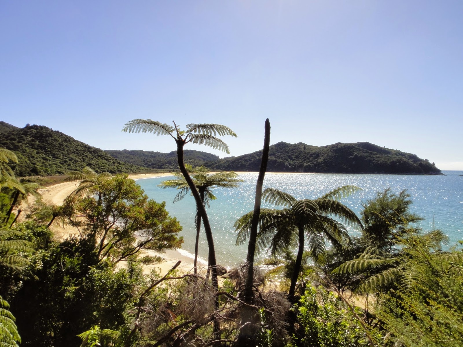
Te Anau Lake 
The Clinton River
The second day was just as nice as the first.  The Clinton Valley became more scenic the deeper you went and we stopped at the riverside for a while to watch some of the other walkers try their luck at fishing for trout.  The river was so perfectly clear that you could see the trout in the water and the shadows they cast from dozens of feet away!  Takes a lot of the guesswork out of it I'd say.  The group didn't have any luck with the trout, but did manage to snag a 3 foot black river eel on the line.  Luckily for the eel, they didn't find the thought of him to appetizing.  Like the Milford Road before, the valley narrowed as we approached the mouth of the river and the 3000+ foot cliffs rising on either side of us proved irresistibly photogenic.  It was as if we were walking through the Yosemite Valley were it roadless and covered with primordial rainforest in place of pine.  No exaggeration! New Zealand has apparently been concealing several valleys that can rival the scenery and grandeur of Yosemite!  The second day ended at the base of the McKinnon Pass at the foot of the oddly crowned Mt Balloon.  Seeing the sunset bleed red onto this sheer cliff from the porch of the hut was amazing.

3 foot river eel - one of many
Looking up the Clinton Valley
Mt Balloon from the deck of our hut
The third day was the most difficult of the hike, being the day we needed to pass the only alpine section of the walk at McKinnon Pass.  It was a relatively short climb to the pass, but the trail conditions made it more difficult.  Apparently the winter passed had been particularly harsh and had caused several landslides and avalanches that destroyed many parts of the trail.  The pass itself felt like winter, as the morning clouds hadn't yet dissipated and the winds whipping over the top gave us chilling reminders of alpine section of the Kepler.  It's a shame, as the view from the shelter on the pass (which has had to be rebuilt some 4 or so times thanks to the ruthless weather) down into the valleys on either side are said to be fantastic.  No worries, as the trail had no shortage of awe inspiring scenery so far.


We pushed over the saddle and began to descend the opposite side to escape the cold.  Just as we came down the clouds began to break up over the mountains, providing mystical views down the unspoiled valley backed by the eerie sound of Keas squawking somewhere in the mist.  It was an unforgettable experience and one of the true highlights of the hike, or even all our time in NZ!  Further down towards the valley floor fantastically blue rivers cascade down smoothed granite boulders in some magical unnamed waterfalls and views of the opposite side of Mt Balloon dominate the end of the valley.  It was a trip to see the pass that we'd just come over rising precipitously for thousands of feet, knowing we'd been up there only a few hours ago.  Just when I thought that the day couldn't get any better we reached the fork with the trail to Sutherland Falls.  Having just walked 5 or 6 hours over a mountain the thought of adding an additional hour to my day's walk wasn't very appealing, but I talked myself into it using my usual method of "when will you ever be here again?".  Kayleigh's inner voice wasn't as persuasive so she looked after our bags in the shelter while I went ahead.


Looking down the Arthur Valley 
Mt Balloon from the other side  


Sutherland Falls is named after its cheerleader, Donald Sutherland (not the one you're thinking of!).  Once believed by Sutherland to be the highest waterfall in the world at over 5,000ft, official measurements come in at 1,904 feet tall.  Despite his gross overestimation of their height, the falls bearing his name are still one of the most impressive waterfalls I've ever laid eyes upon (I admittedly haven't seen Yosemite Falls).  Cascading down in three long drops from a hidden lake above, it was totally worth the extra time and effort it took to get there.  Back to Kayleigh and with backpack strapped on again we did the last hour to the final hut of the walk. 


Sutherland Falls from the foot
Further along the main trail gives you this view
On the first night of our hike the hut warden had told us that hardly a group gets through the entire walk without a bit of rain and we proved no exception. The next day our streak of perfect weather broke.   If you ask me we're incredibly lucky that the rain hadn't come until that day, since it was the flattest and easiest of the days.  Had it come the day before it would have been a dangerous, slippery and miserably cold push over the pass.  When it came though, it came hard.  Despite all our fancy rainproof clothing, the moisture found its way in and we were soaked to the bone.  It also came with some surprises, as the precipitous mountains around us transformed into flowing walls of water that were so numerous they were impossible to quantify!   It was in this vein that we traveled the remaining 16km to Sandfly Point, passing two marked waterfalls (Mackay and Giant's Gate) and an infinite number that had spontaneously sprung into existence, one of which was so wide and raged so hard that it beat out Sutherland Falls as the most impressive waterfall I've ever seen.

Mackay Falls
Tada! A waterfall appeared!
The view from Sandfly Point
Milford Sound in the rain
Overall I would have to concede that the Milford Track is probably the best hike I've ever done and certainly the most beautiful.  Does that make it the finest walk in the world? I don't know, but I plan to do my best to find out :)

A few more things to note:
-Sandfly Point completely lives up to its name.  This was the worst area for sandflies in any place in all of NZ before or after this hike by an order of magnitude.  All one could really do was laugh to avoid a mental breakdown.
-The Milford Sound was much better the second time through, as the mist and waterfalls added a lot to the sense of ambience.  Maybe the fact that we were on the water also had something to do with it.
-Milford Highway had been completely transformed.  As we were shuttled back to our car we were overtaken with the falling water coming from every surface.  Someone should have named it "Valley of A Thousand Waterfalls".     

-There is tons of interesting history about this region for those of you who may be interested.  From the beginnings of the Milford Track to the opening of the Milford Road, here are few kew words to aid your search: Donald Sutherland, Milford Track, Milford Road, Homer Tunnel, Sutherland Falls, John Mackay, Quintin McKinnon.